Wednesday, April 29, 2015

Why Box-Death Hollow?

For the name of a Wilderness Area? Well fans, (all twenty of you including hackers) I'm glad you asked. 

Death Hollow scored the scary moniker for all the livestock who plunged to their untimely demises while attempting to cross this sharply angled canyon. In other words, it's crazy steep. There's no mention of any salvage operations for the pulverized burgers or mutton. I guess the fresh protein was a treat for the local cougar. 

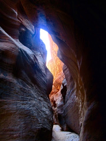
I chose the much mellower Box Canyon for today's wanderings. This big view canyon was formed by Pine Creek's constant liquid flow. I even saw fish in the waterway.  In fact, the only other creatures I sighted in 4.5 hours was a few frisky squirrels, some flittering birds and a scattering of lizards. There were no other humans around in this part of Utah. Now, that's a wilderness experience!

I'm kind of falling in love with the Grand Staircase - Escalante National Monument. Isn't there anyone out there who might be interested in a fall backpack trip here? You hackers are invited too! The autumn colors would be beyond awesome. Probably bordering on tubular, Dude. 

The slot canyons are calling...

Tuesday, April 28, 2015

While growing up...

In the Bronx, our early American history lessons were geographically eastern based. It was all about the Original Thirteen Colonies strung out along the Atlantic Ocean side. 

It wasn't until I made the great leap west in 1978, did I begin to realize there was heaps of White Folk history on the other side of this continent. The only difference was the White Folk spoke Spanish instead of English. 

In 1776, (isn't that year significant in U.S. History?) Fathers Dominguez and Escalante left Santa Fe, New Mexico in an attempt to find a route to the Catholic missions in Monterey, California. They endured hunger, cold, thirst and other hardships while traversing a harsh landscape. They were the first Non-Natives to see a significant part of the Colorado Plateau country. They left behind a few names of the rivers they crossed: the Dolores, the San Miguel and the Mancos. Their brave efforts failed to gain them the prize they sought. They returned to Santa Fe to a less than warm welcome. They were looked upon as losers.

So, it's a little ironic that the one River they didn't ford or even see is named after Father Escalante. Kudos to Almon Thompson who mapped and named the river in 1872. This humble river (only 90 miles long) was the last waterway of its size to be discovered in the Lower 48. Thanks Almon for not being a suck-up and naming the river after your boss - John Wesley Powell. 

I forded the Escalante River today over and over. I have photos to prove it too. Please don't look at me as a failure for not making it to Monterey. 

There is so much to see in the 1.9 million acre Grand Staircase - Escalante National Monument. I'll be doing some exploring in the days to come. Anyone interested in backpacking here this fall?

In the final photo, a few knockoffs of Casey Nocket left their sign in a beautiful alcove. Shame on them. http://jeffsambur.blogspot.ae/2014/11/the-case-against-casey-nocket.html

Be nice out there. 
Jeff

BTW. The W,W Jew blog just scored its 15,000th page view. So what, if many of those hits came from Eastern European hackers! Maybe they read my stuff in between sniffing around for my password. 

Why can't we all just get along? 


Sunday, April 26, 2015

"So, Mama don't take my Kodachrome away..."

Kodachrome by Paul Simon.

It was a chilly, blustery day at Kodachrome Basin State Park. I donned tights, lots of layers and a Windstopper jacket to brave the elements for my ramble. I miss my shorts and tank tops! 

So Jeffy, how did this park get named for a now extinct Kodak color film? I'm glad you asked because I'm in Cannonville, Utah (Yawn!) and I have plenty of time to expound.

Back in 1948, a squad of National Geographic Society photographers descended upon the area. One Jack Breed piped up, "It was a beautiful and fantastic country...we renamed it "Kodachrome Flat" because of the astonishing variety of contrasting colors in the formations."

Personally, I think "Mostly Mud-Colored Rock Flat" would be more accurate, but Jack was here first. 

At that time, Kodachrome film was fairly new on the scene. (Maybe NGS was scoring some payola from Kodak!). In 1962, the land was deeded to the Beehive State for use as a park. A little later, Utah was granted the OK by Kodak to use Kodachrome as the name. Why not? Free advertising! 

In 2009, Kodak discontinued production of Kodachrome. Digital cameras made film obsolete. Future generations will one day say, "Daddy/Mommy! What's Kodachrome?"
You're a Baby Boomer if you know what a Brownie camera is!

The wind can stop anytime now...

From downtown Cannonville, Utah, yawn...


Saturday, April 25, 2015

The Land of Giddy...

If Zion National Park is the Land of Make-Believe http://jeffsambur.blogspot.ae/2015/04/a-make-believe.html than Bryce Canyon National Park is a Land of Happy Hikers. Grins are  prevalent except on the steep climbs. The visitors aren't happy then. But when they halt mid-stride and look around, they'll usually smile again. It's a place to let your imagination run wild. 

Didn't that rock look like a camel's head? Wasn't that Queen Victoria over yonder? Is that a couple in the act of coupling to the left of that pine tree? The Hoodoos (the name for the eccentric rock formations) won't say.

The Paiute Indians believed the stones were the Legend People. However, they were evil in nature. The trickster Coyote turned them into crumbly columns for their digressions. The story is a Native American knockoff of Lot's Wife and the Pillar of Salt. I guess humanity has only so many yarns.

It's a park in constant transition. The rock is sedimentary and soft. Every time it rains (like today) or White Death descends from the sky, a little more is flushed away into the Paria River drainage. So you better hurry to catch this whimsical place before its a geologic memory. 

BTW:  the park is not a canyon, it's an amphitheater. In the 1870's a Mormon pioneer named Ebenezer Bryce helped build a road to the rim and its bounty of timber. His neighbors called it Bryce's Canyon.
Old Ebenezer is credited with describing the nearby turf this way, "it's a hell of a place to lose a cow!" 

From rainy Tropic, Utah.
It's Saturday, (the Hebrew Sabbath) this Wandering, Wondering Jew is taking a day of rest here. 
Hark! Is that an IPA calling me?


Friday, April 24, 2015

A Make-Believe...

Landscape is how I describe Zion National Park. Regardless of the viewpoint or the season, that one thought never changes. This place can't be real. 

Spires, turrets, pyramids, canyons, vertical slabs, one Virgin River, mesas, rock slides, a few mammals and birds, it's all here. Paint it all with colors ranging from subtle pastels to Peter Max Day-Glow pigments. To this mix, add heaps of tenacious pine trees that eke out a living in a few scoops of substrate. Their deep green hues put the finishing touch to the whole well orchestrated scene. Simply Amazing. 

When I see Zion, I want to shout "Encore! Encore!" 

But there is only one Zion National Park in the world. That is why the world comes to Southwest Utah. It's not for the brewpubs. Real brewmasters live elsewhere. 

I've walked 33 miles in three days here. I'm growing older but Zion never grows old. When I return, I'll think once again, "this place can't be real!" 

Excuse me, I've got to look up and gawk now.

Cheers from beyond the Zion Curtain,
Jeff

A note about the pics: 
On Angel's Landing at rush hour. It'll be within a few years, that too will require a permit. Looks like a traffic cop is needed there.

The tilted tree obviously got into my Imperial IPA stash. It was standing straight and tall before it imbibed. For those of you who are concerned, I'm down to two cases of brew. I think I have enough to get me to the Colorado border. I'm kind of worried about my coffee supply though. 

I love the squirrel notice on the buses. It's great the NPS has a sense of humor at times. 

Get out here before you need a visa to see it.
Bye

Tuesday, April 21, 2015

0 for 2 on the...

Wave lottery.

While I sat in the auditorium watching the winners smile as the losers fidgeted, I fast-forwarded this scene to future generations. I feel sorry for them. 


In the early 30's, Everett Ruess wandered in the Southwest untrammeled by crowds or regulations. It was a unfenced landscape. There were no required permits for his wilderness sorties then. He disappeared in 1934. America's population was 126 million.

In 2015, I wander around via Barley the Van instead of a mule like Everett. Popular hiking trails are rife with people. So much for the wilderness experience. The really sought after destinations like the Wave require a permit for the pleasure of photographing them. My future outdoor plans require at least three permits for me to play in the Great Outdoors. America's population is now 319 million. 

More people are reaching for the same piece of pie. Sadly, the slice is not getting any bigger.

Today I hiked Lick Wash. It was an airy, big view canyon for the most part. Certain sections even contained twinges of Zion National Park. There are no permits required except for overnight stays. I saw no one in 8 miles. I saw one snake though.  I think it'll be just a matter of time before hikers will have to go online to secure a permit to see it. 

I'm glad I was born in 1954 instead of 1994. 
I know, a very sobering blog. 

Jeff


Monday, April 20, 2015

Close but no...

Wave Permit.

The lottery process for scoring a much coveted Government OKAY is similar to a Bingo game.
You fill out an application, and a number is assigned to you. The numbered balls begin to roll in a Ball-O-Matic silver cylinder. One wooden ball is expelled at a time. My # was 
5. Lucky Winner #6 was drawn. No one had the moxie to shout "Bingo!" The losers in the audience might have throttled him or her.

So...I had to make other hiking plans. Originally, I was thinking about the starting segment of the Arizona National Scenic Trail. When I saw the route from the parking lot, it looked as boring as a slice of Wonder Bread with Parkay margarine slathered on it. Nope. Not today.

I doubled back to Wire Pass and hiked a small segment of Buckskin Gulch. BG is famous for  being the longest slot canyon in the world. It's usually wet, slimy, muddy and no place for the claustrophobic. A flash flood here would do more than ruin your day. 

I'll try my luck again this morning. However I fear my chances are as rare as discovering a 60 year old Jewish man living in a van down by the river. Doh! 

I included a web shot of the Wave. See what I'm missing? That sign will probably be as close as I come to it this go-around.

Happy Monday,
Jeff