off.
Was about the most positive thing I could think of when an uneventful day of hiking became an eventful day.
After four nights of blissful, quiet camping northwest of Lake City, I checked the maps to see if I could do an short, easy hike before driving back home to Durango. I was in luck. The Colorado Trail and the Continental Divide Trail bisected Spring Creek Pass on Highway 149. Bingo!
Heading east from the Pass would take me to Snow Mesa. My National Geographic map showed the trail was just south of the Continental Divide where Baldy Cinco resided. It’s a prominence of 13,379’. Surely there must be a social trail heading off the CT/CDT to gain those peaks.
It was a forested uphill slog to the lip of the Mesa. What I saw then was Kansas flatness (minus the wheat) stretching out for miles. It was also compellingly beautiful. To my left, were the peaks. I kept looking for a trail heading off toward them. None. I decided to go cross country aiming for a saddle between the two high lumps. I angled up along the tussock grass towards what I thought was the higher Baldy Cinco. It was steep. On top I was rewarded with Colorado county size views and an eight foot rock cairn. I pulled out my PB&J sandwiches and my map. I checked out the surrounding region. Hmmm...that must be the Skyline Trail on the lower saddle just below me.
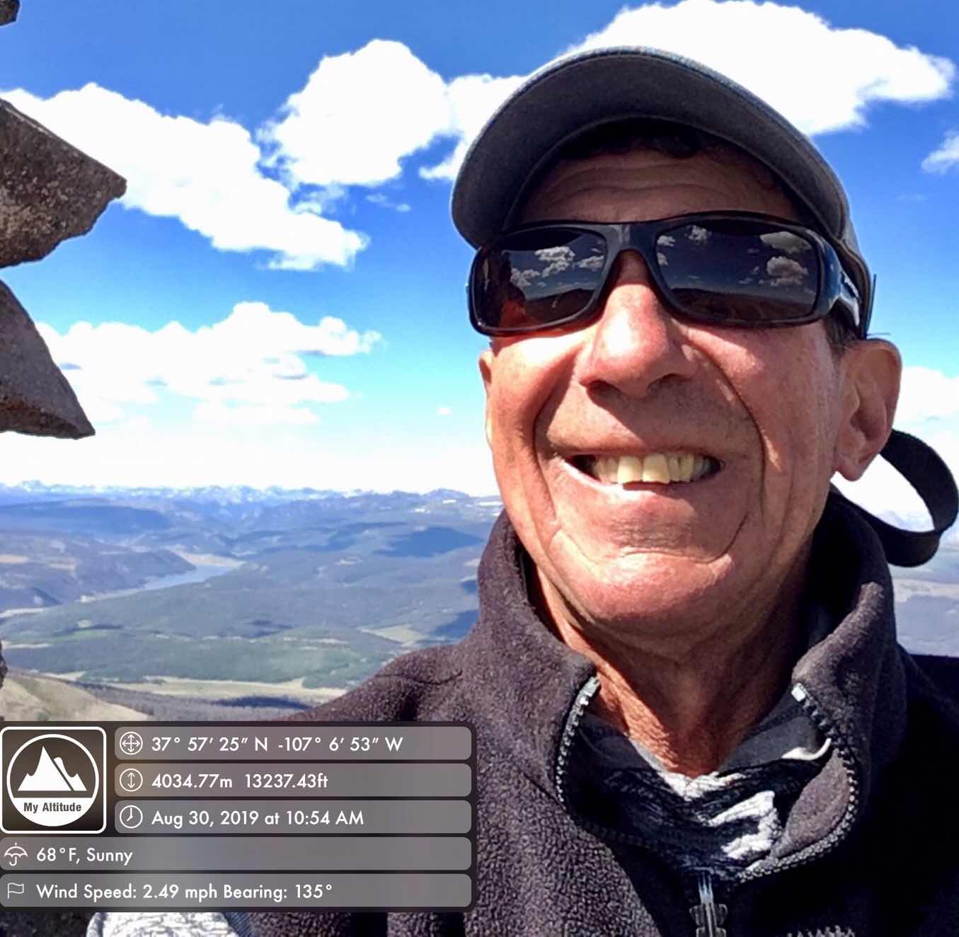
At 10:54 am, I sent my family a selfie summit shot wishing them all “a safe and happy Labor Day Weekend.” A few minutes later, I did the same for my billions of Facebook fans. I repacked my gear and headed downhill.
Later on I realized I summited “No es Baldy Cinco.” ( A lovable local name). At 13, 227’, it’s still pretty impressive rising out of the somewhat featureless tableland.

It took awhile before I gained the level ground again. I walked perpendicular to the peaks figuring I’d run into the CT/CDT. I didn’t. How could that be? They were around here hours ago. Who took them? I walked some more across the eye catching sameness. Still nothing. I sat down, pulled out my map and tried to figure out where I was. I wish I could say I was Sir Ernest Shackleton cool, but I wasn’t. This is what I knew. I couldn’t find what I was looking for. I knew there seemed to be a trail near the top of “No es Cinco Baldy.” I made a quick game plan. I’d ascend the prominence again and exit out what I figured was the Skyline Trail. So that’s what I did.

Skyline Trail? petered out in no time. I followed the lay of the land knowing (according to my map) the trail eventually plunges down the Tumble Creek drainage. At a lower saddle, I stumbled upon a solid looking trail. I pulled out my phone, I had two bars and 80% battery power. After opening the “My Altitude” app, I ascertained the coordinates and the elevation. I scrawled the info on my map. (Yes, a pen is survival gear.) I called 911. It was 2:14 pm.
“911. What is your emergency?”
“I’m not quite sure of my location near Baldy Cinco. I have my coordinates and elevation and was hoping you could tell me if I’m on Skyline Trail. I’m sure you have better access to a topo map than I do.” She didn’t really know what to do, so she forwarded my call to the Hindsdale County Sheriff.

I spoke to a young sounding sheriff who quickly passed the phone to an older sounding one. He took my coordinates and went to work.
It took some time as I watched my battery power decline, “So? Am I on the Skyline Trail?”
“Yes. Stay on it and eventually you will come out to a dirt road. Highway 149 is about two miles away.”
“OK. I’ll call you back so you know I made it out. If not come looking for me. You have my last set of coordinates.”
The trail sputtered and popped. Sometimes it resembled a ghost vanishing act, sometimes a deer/elk/cattle track other times well trodden. I kept moving. No breaks. No giving myself a high five and breaking out the IPA and cake. I stayed focused. I wasn’t out of this yet. Two hours later, I came across the following sign. I knew where I was now. I took a sip of tepid water. Two hitch hikes later, I was back in my van. The time was 4:46 pm.

Here’s what I did wrong.
In my haste to make “No es Baldy Cinco”, I was focused on the summit goal. I wasn’t turning around to pick out meager landmarks on where I left the CT/CDT. My bad.
I got cocky. I was in unfamiliar territory. I needed to pay more attention, not less. I’ve had a string of no problem years of hiking (for the most part) without losing my way. I became temporarily immune to screwing up.
Here’s what I did right.
I got an early start. I moved quickly. World famous mountaineer Ed Viesturs wrote in “No Shortcuts to the Top,” speed is a safety factor. Being quick buys you time. Getting
farblondzhet (lost in Yiddish) is better when there’s six hours of daylight left, then at sunset. It’s the same if an injury slows you down.
I carry enough gear to survive a night out. My day pack is the weight of many ultra lite aficionados multi-day backpacks. I had a Windstopper hoodie jacket and three layers of fleece. For eats, there were two Clif Bars and two spare oranges. I pocket a map for the big picture. I have a Bic lighter to start a warming fire. I had a pen. I carried a cell phone which I leave off 95% of the time. It would have been an IPA-less and coffee in the morning less experience, but I probably would have survived. I DO NOT carry a Swiss Army Knife to cut off my arm. (My apologies to Aron Ralston).
I did not “bend the map.” In Laurence Gonzales’ thought provoking read, “Deep Survival” he mentions the term. In other words, making what you want to believe fit the reality of the map. (Not that Sari or maps are irrefutable). I thought I knew where I was (Skyline Trail) but I called 911 for a second opinion. It worked out this time due to cell phone coverage and a Sheriff who did the leg work of checking my position.
It’s not easy writing a blog in which I admit to making a lot of mistakes. Yet, I did write it. If this blog gets the attention of one person, maybe they will avoid the errors I made, After all, I’m past the age of going into burning buildings and performing other crazy acts of heroism to make a difference.
Please have a safe and happy Labor Day Weekend. What’s left of it.
BTW. Can anyone recommend an app to keep me on the trails?
Cheers,
Jeff marked safe and sound in Durango, CO.
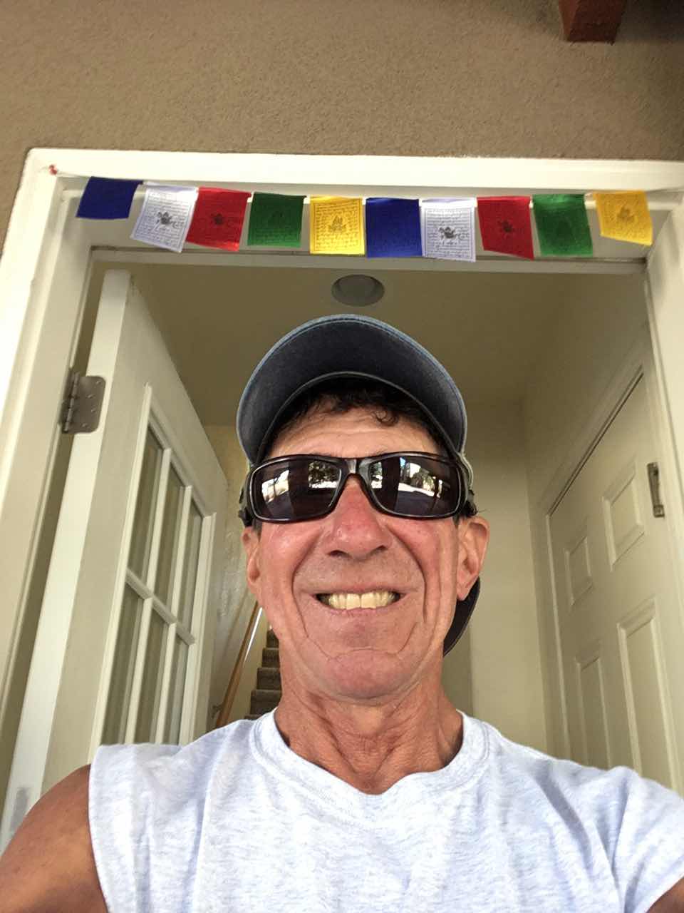
Last photo.
I have prayer flags watching my back.
Good to hear that you are back, safe and sound. Happy Labor Day!
ReplyDeleteOh my. Stay safe and put.. just a little! Enjoy the weekend!
ReplyDeleteYou’re smart to call 911 most people wouldn’t have thought of that! I know this info is relevant. perhaps post on 14ers.com or if there is a 13ers.com these notes could be helpful to other climber/hikers. Enjoy your Labor Day! Don’t work so hard!
ReplyDeleteJeff great story and to hear an adventure of yours had big challenges and your lessons learned too. Amazing your cell phone worked and you were provided guidance along the way 🌎
ReplyDeleteViewRanger
ReplyDeleteI think AllTrails doesn’t need WiFi! Thanks for this great read and happy you’re smart and safe! ;)
ReplyDeleteCOTREX is an app put out by the state of CO that has all the hiking trails on it. Thanks for the humbling message. Things can go south in a heartbeat. I assume you always carry your CO search and rescue card? I never hit the trails without mine
ReplyDeleteCOTrex is getting better all the time and is free. Otherwise, maybe AllTrails free version or pay for one of the premium versions of GAIA, ViewRanger, etc.
ReplyDeleteGaiaGPS is the best smartphone app. I've used it for over three years and love. Well worth the "membership" subscription cost. To me it's even more essential than a paper map.
ReplyDelete